Ring Of Kerry on:
[Wikipedia]
[Google]
[Amazon]

 The Ring of Kerry ( ga, Mórchuaird Chiarraí) is a circular tourist route in
 Sat-Navs sending Kerry bus drivers astray
/ref>
Ring of Kerry Scenic Drive and Cycle Route Map and Photos
* {{DEFAULTSORT:Ring Of Kerry Geography of County Kerry Tourist attractions in County Kerry

 The Ring of Kerry ( ga, Mórchuaird Chiarraí) is a circular tourist route in
 County Kerry
County Kerry ( gle, Contae Chiarraí) is a county in Ireland. It is located in the South-West Region and forms part of the province of Munster. It is named after the Ciarraige who lived in part of the present county. The population of the co ...
, south-western Ireland
Ireland ( ; ga, Éire ; Ulster Scots dialect, Ulster-Scots: ) is an island in the Atlantic Ocean, North Atlantic Ocean, in Northwestern Europe, north-western Europe. It is separated from Great Britain to its east by the North Channel (Grea ...
. Clockwise from Killarney
Killarney ( ; ga, Cill Airne , meaning 'church of sloes') is a town in County Kerry, southwestern Ireland. The town is on the northeastern shore of Lough Leane, part of Killarney National Park, and is home to St Mary's Cathedral, Ross Castl ...
it follows the N71 to Kenmare
Kenmare () is a small town in the south of County Kerry, Ireland. The name Kenmare is the anglicised form of ''Ceann Mara'', meaning "head of the sea", referring to the head of Kenmare Bay.
Location
Kenmare is located at the head of Kenmare ...
, then the N70 around the Iveragh Peninsula
The Iveragh Peninsula () is located in County Kerry in Ireland. It is the largest peninsula in southwestern Ireland. A mountain range, the MacGillycuddy's Reeks, lies in the centre of the peninsula. Carrauntoohil, its highest mountain, is als ...
to Killorglin
Killorglin () is a town in County Kerry, Ireland. As of the 2016 CSO census, the town's population was 2,199. Killorglin is on the Ring of Kerry tourist route, and annual events include the August Puck Fair festival, which starts with the crown ...
– passing through Sneem
Sneem () is a village situated on the Iveragh Peninsula (part of the Ring of Kerry), in County Kerry, in the southwest of Ireland. It lies on the estuary of the River Sneem. National route N70 runs through the town. While the 2016 census recor ...
, Waterville, Cahersiveen
Cahersiveen (), sometimes Cahirciveen, is a town on the N70 national secondary road in County Kerry, Ireland. As of the 2016 CSO census, the town had a population of 1,041.
Geography
Cahersiveen is on the slopes of 376-metre-high Bentee, and ...
, and Glenbeigh
Glenbeigh or Glanbehy () is a town and civil parish on the Iveragh peninsula in County Kerry, Ireland. The parish includes Rossbeigh beach, Coomasahran Lake and a number of important rock art sites. Owing to its natural heritage, history and i ...
– before returning to Killarney via the N72.
Popular points include Muckross House
Muckross House ( ga, Teach Mhucrois) is located on the small Muckross Peninsula between Muckross Lake and Lough Leane, two of the lakes of Killarney, from the town of Killarney in County Kerry, Ireland. In 1932 it was presented by Willia ...
(near Killarney), Staigue stone fort and Derrynane House
Derrynane House () was the home of Irish politician and statesman, Daniel O'Connell. It is now an National Monument and part of a 320-acre (1.3 km²) national historic park. The house is located on the Iveragh peninsula on the Ring of Kerry ...
, home of Daniel O'Connell
Daniel O'Connell (I) ( ga, Dónall Ó Conaill; 6 August 1775 – 15 May 1847), hailed in his time as The Liberator, was the acknowledged political leader of Ireland's Roman Catholic majority in the first half of the 19th century. His mobilizat ...
. Just south of Killarney, Ross Castle
Ross Castle ( ga, Caisleán an Rois) is a 15th-century tower house and keep on the edge of Lough Leane, in Killarney National Park, County Kerry, Ireland. It is the ancestral home of the Chiefs of the Clan O'Donoghue, later associated with th ...
, Lough Leane
Lough Leane (; ) is the largest of the three lakes of Killarney, in County Kerry. The River Laune flows from the lake into the Dingle Bay to the northwest.
Etymology and history
The lake's name means "lake of learning" probably in reference ...
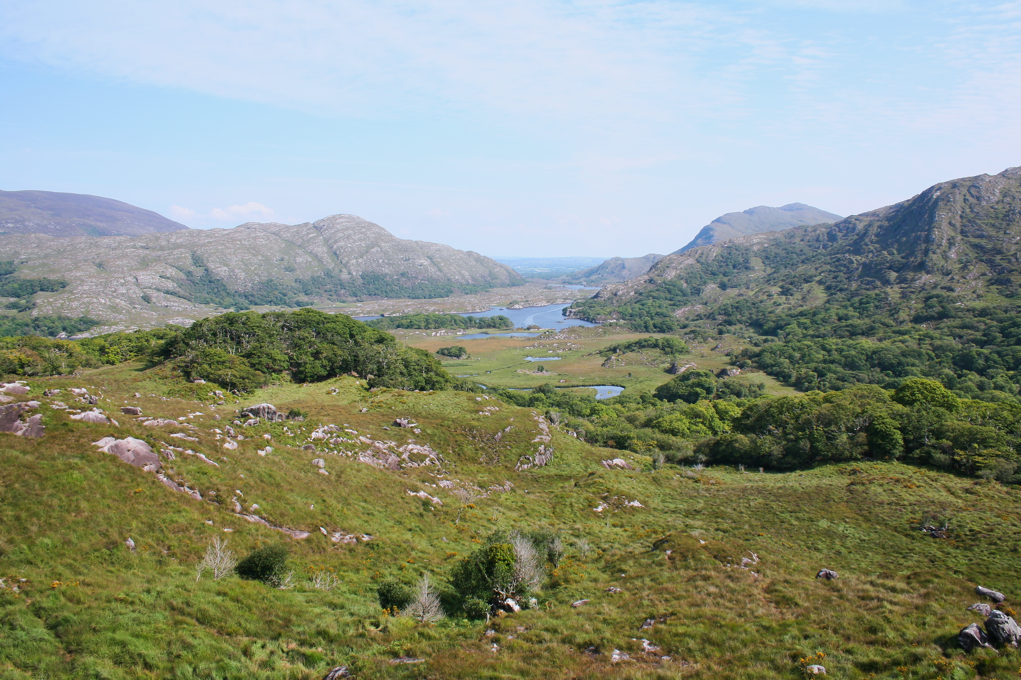
, and Ladies View
Ladies View is a scenic viewpoint on the Ring of Kerry tourist route about from Killarney along the N71 road to Kenmare, in the Killarney National Park in Ireland. The ''Irish Times'' ranked Ladies View as one of the most photographed places ...
(a panoramic viewpoint), all located within Killarney National Park
Killarney National Park ( ga, Páirc Náisiúnta Chill Airne), near the town of Killarney, County Kerry, was the first national park in Ireland, created when the Muckross Estate was donated to the Irish Free State in 1932. The park has sinc ...
, are major attractions located along the Ring. A more complete list of major attractions along the Ring of Kerry includes: Gap of Dunloe
The Gap of Dunloe (), also recorded as ''Bearna an Choimín'' (meaning "gap of the commonage" or "gap of the little hollow"), is a narrow mountain pass running north-south in County Kerry, Ireland, that separates the MacGillycuddy's Reeks mounta ...
, Bog Village, Dunloe Ogham Stones
Dunloe Ogham Stones (CIIC 197–203, 241) is a collection of ogham stones forming a National Monument located in County Kerry, Ireland.
Location
Dunloe Ogham Stones are located 1 km south of Beaufort, to the south of the River Laune
...
, Kerry Woollen Mills
Kerry Woollen Mills are historic wool mills based just off the Ring of Kerry.
History
Kerry Woollen Mills are one of the last remaining traditional wool mills still manufacturing in County Kerry. The company was founded over 300 years ago. T ...
, Rossbeigh Beach
Rossbeigh, or Rossbehy (Irish: ''Ros Beithe'', meaning "headland of the Birch trees") is a sandspit with beaches on either side, located approximately 1.6 km from the village of Glenbeigh, in County Kerry, Ireland. It is on the Ring of K ...
, Cahersiveen Heritage Centre, Derrynane House, Skellig Experience, Staigue Fort, Kenmare Lace, Moll's Gap
Moll's Gap or Céim an Daimh (meaning, Gap of the Ox), is a mountain pass on the N71 road from Kenmare to Killarney in Kerry, Ireland.
Moll's Gap is on the Ring of Kerry route, and offers views of the MacGillycuddy's Reeks mountains, and is ...
, Ballymalis Castle
Ballymalis Castle is a tower house and National Monument located in County Kerry, Ireland.
Location
Ballymalis Castle is located northwest of Beaufort, on the north bank of the River Laune, near its confluence with the River Gaddagh. The Ri ...
, Ladies View, Torc Waterfall
Torc Waterfall () is a high, long cascade waterfall formed by the Owengarriff River as it drains from the '' Devil's Punchbowl'' corrie lake at Mangerton Mountain. The waterfall, which lies at the base of Torc Mountain, in the Killarney Nati ...
, Muckross House, The Blue Pool, Ross Castle, Ogham
Ogham (Modern Irish: ; mga, ogum, ogom, later mga, ogam, label=none ) is an Early Medieval alphabet used primarily to write the early Irish language (in the "orthodox" inscriptions, 4th to 6th centuries AD), and later the Old Irish langua ...
Stones, St Mary’s Cathedral, Muckross Abbey
Muckross Abbey (Irish: ''Mainistir Locha Léin'' and ''Mainistir Mhucrois'') is one of the major ecclesiastical sites, found in the Killarney National Park, County Kerry, Ireland. It was founded in 1448 as a Franciscan friary for the Observa ...
, Franciscan Friary, Kellegy Church, O’Connell Memorial Church, Sneem Church and Cemetery, Skellig Michael
Skellig Michael ( ga, Sceilg Mhichíl ), also called Great Skellig ( ga, link=no, Sceilig Mhór ), is a twin-pinnacled crag west of the Iveragh Peninsula in County Kerry, Ireland. The island is named after the archangel Michael, with "Skellig ...
(off the coast), Beehive Cells and the Stone Pillars marking an important grave.
There is also an established walking path named The Kerry Way
The Kerry Way () is a long-distance trail in County Kerry, Ireland. It is a long circular trail that begins and ends in Killarney and is typically broken into nine stages. It is designated as a National Waymarked Trail by the National Trails Of ...
, which takes its own route, and a signposted Ring of Kerry cycling path which uses older quieter roads where possible. The Kerry Way roughly follows the scenic driving route of the Ring of Kerry.
There are numerous variations to the route taking in St. Finian's Bay and Valentia Island
Valentia Island () is one of Ireland's most westerly points. It lies off the Iveragh Peninsula in the southwest of County Kerry. It is linked to the mainland by the Maurice O'Neill Memorial Bridge at Portmagee. A car ferry also departs from R ...
which the official driving ring misses (the official cycling route takes in Valentia Island). As well as beaches, it also offers the Gap of Dunloe, Bog Village, Derrynane House, the Skellig Experience Valentia Island, Moll's Gap, Torc Waterfall, Muckross House, and Ross Castle.
"The Ring" is a popular day trip and numerous bus companies offer circuits during the summer months. As the narrow roads make it difficult for tour coaches to pass one another, all tour buses run in an anti-clockwise direction, travelling via Killorglin first. Some recommend that car owners travel in the opposite direction, going first to Kenmare to avoid delays caused by tour buses. Others advise travelling counter-clockwise to avoid having to pass the buses. In 2008 satellite navigation systems
A satellite navigation or satnav system is a system that uses satellites to provide autonomous geo-spatial positioning. It allows satellite navigation devices to determine their location (longitude, latitude, and altitude/elevation) to high pr ...
were blamed for directing bus drivers in a clockwise direction around the route./ref>
References
Further reading
*External links
*Ring of Kerry Scenic Drive and Cycle Route Map and Photos
* {{DEFAULTSORT:Ring Of Kerry Geography of County Kerry Tourist attractions in County Kerry